


RTKGPS+
Beschreibung von RTKGPS+
+++++++++++++ DISCLAIMER ++++++++++++++
THIS IS AN ALPHA VERSION
I received some requests to move it to a production
version, for my point of view it works but this version
lacks some extensive tests.
However I changed it to public with this disclaimer.
IT IS PROVIDED AS IS...
WITHOUT ANY WARRANTY.
++++++++++++++++++++++++++++++++++++++
Android RTKLIB frontend.
source code can by downloaded on https://github.com/eltorio/RtkGps
Heavily based on RtkGps from Alexey Illarionov, this is a fork of his work. He allows explicitly to modify and redistribute his work only with the distribution his copyright. You'll find the original license in the "About/Legacy Info" screen. Thanks to all contributors to respect this original license clause.
Since there is no new version I reworked the code for adding some features I need:
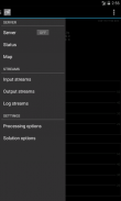
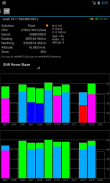
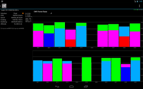
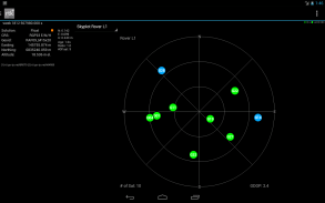
1- show the altitude in the status view.
for activating this you need to choose Height:Geodetic in the "Solution Options" view
2- send mock locations to other applications.
for activating this you need to check in the "Solution Options" view Output GPS mock locations, but this is only working if you have allowed "mock locations" in the developer settings (in Android setting).
today (in 1.0alpha13) the mock locations are not usable in the Google map API.
3- automatically upload log file or solution file to your Dropbox account
4- can generate a gpx file of the track
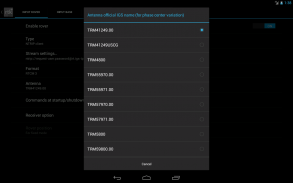
5- can display the result in ECEF, WGS84 Lat/Lon, NAD83, Lambert 93 (RGF93) or UTM (with auto zoning) coordinate system
5b- use any Proj4 projection
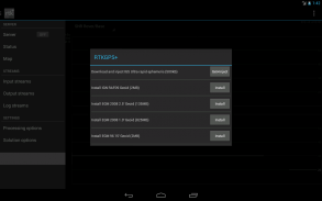
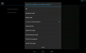
6- can display ellipsoidal height or geodetic altitude (different geoid models can be use see: https://github.com/eltorio/RtkGps for how to install a geoid model)
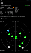
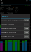
7- use any RTKLIB compliant GNSS with raw output connected via USB (ACM/PL2303/FTDI), Bluetooth, TCPIP or NTRIP
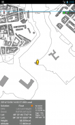
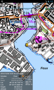
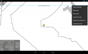
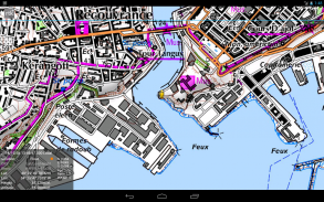
8- can display some maps coming from IGN Geoportail (cadastral parcels, satellite, roads), OpenStreetMap Mapnik, Bing (satellite, roads).
9- can download and use IGS ultra-rapid ephemeris
This software is a port of RTKLIB 2.4.2p9 developed by Tomoki Takasu (http://www.rtklib.com), if you do not know what this application is; this application is probably not what you are looking for!
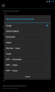
This application can compute precise GPS positions using RTKLIB algorithms (RTK or PPP) but for this you need a supported -external- GPS with raw carrier phase output.
This is not a "standard" GPS like those embedded into your phone or your car, the cheapest one you can find is something like uBlox LEA-6T .
THERE IS NO WAY to use the GPS found in Samsung Galaxy(s) nor any phone I seen.
But there is a special test mode witch use the internal GPS for testing only, obviously none of the precision algorithm found in RTKLIB can be use.
+++++++++++++ HAFTUNGSAUSSCHLUSS ++++++++++++++
Dies ist eine Alpha VERSION
Erhielt ich einige Anfragen, um es zu einem Produktions bewegen
Ausführung, für meiner Sicht funktioniert es aber diese Version
fehlen einige umfangreiche Tests.
Allerdings habe ich es zu öffentlichen mit diesem Haftungsausschluss.
Es ist vorgesehen, wie ...
OHNE GARANTIE.
++++++++++++++++++++++++++++++++++++++
Android RTKLIB Frontend.
Quellcode kann auf https://github.com/eltorio/RtkGps heruntergeladen von
Stark auf RtkGps von Alexey Illarionov basiert, ist dies eine Gabel von seiner Arbeit. Er lässt ausdrücklich zu modifizieren und zu verteilen sein Werk nur mit der Verteilung sein Urheberrecht. Sie werden die Original-Lizenz in der "Über uns / Legacy-Info"-Bildschirm zu finden. Vielen Dank an alle Mitwirkenden an diesem ursprünglichen Lizenzklausel zu respektieren.
Da es keine neue Version, die ich überarbeitet den Code für das Hinzufügen einiger Funktionen, die ich brauche:
1- zeigen die Höhe in der Statusansicht.
für die Aktivierung benötigen Sie, um Höhe zu wählen: Geodätische in der Ansicht "Lösungsoptionen"
2 senden Falsche Standorte in andere Anwendungen.
für die Aktivierung benötigen Sie, um in den "Lösungsoptionen" Ansicht Output GPS Falsche Standorte zu überprüfen, aber das funktioniert nur, wenn Sie "Falsche Standorte" in den Entwicklereinstellungen erlaubt haben (in Android-Einstellung).
heute (in 1.0alpha13) die Falsche Standorte sind nicht in der Google-Karte API nutzbar.
3 automatisch Log-Datei oder Lösung Datei auf Ihrem Dropbox-Konto hochgeladen
4 kann eine GPX-Datei der Spur erzeugen
5-kann das Ergebnis in ECEF, WGS84 Lat / Lon, NAD83, Lambert 93 (RGF93) oder UTM (mit Auto-Zoning) anzuzeigen Koordinatensystem
5B- jede Proj4 Projektion verwenden
6 kann Ellipsoidhöhe oder geodätische Höhe angezeigt (verschiedene Geoid-Modelle können Verwendung finden Sie unter: https://github.com/eltorio/RtkGps, wie Sie ein Geoid-Modell zu installieren)
7-Nutzung jeder RTKLIB konforme GNSS mit rohen Ausgabe über USB (ACM / PL2303 / FTDI), Bluetooth, TCPIP oder NTRIP verbunden
8- können einige Karten aus IGN Geoportail (Katasterparzellen, Satelliten-, Straßen), OpenStreetMap Mapnik, Bing (Satellit, Straßen) anzuzeigen.
9- herunterladen und verwenden können IGS ultra-schnelle Ephemeriden
Diese Software ist eine Portierung von RTKLIB 2.4.2p9 von Tomoki Takasu (http://www.rtklib.com) entwickelt, wenn Sie nicht wissen, was diese Anwendung ist; Diese Anwendung ist wahrscheinlich nicht das, was Sie suchen!
Diese Anwendung kann präzise GPS-Positionen mit RTKLIB Algorithmen (RTK oder PPP) zu berechnen, aber für diese müssen Sie eine unterstützte -external- GPS mit rohen Trägerphasenausgang benötigen.
Dies ist keine "normale" GPS wie die in Ihrem Telefon oder Ihr Auto eingebettet ist, ist das billigste finden Sie so etwas wie uBlox LEA-6T.
ES GIBT keine Möglichkeit, die GPS in Samsung Galaxy (n) noch eine Telefon ich gesehen gefunden zu verwenden.
Aber es gibt einen speziellen Testmodus Hexe das interne GPS nur für die Prüfung, offensichtlich nichts von der Präzision Algorithmus gefunden RTKLIB verwenden können.
RTKGPS+ – Version 1.0 Alpha 26
(10-04-2020)RTKGPS+ – APK Informationen
APK Version: 1.0 Alpha 26Paket: gpsplus.rtkgpsNeueste Version von RTKGPS+


 3.64
3.64


Apps in derselben Kategorie

Das könnte dir auch gefallen...


